
Rack followed ruin and ruin begat rack.
Edinburgh is held to be among the most beautiful cities in the world. The sweeping curves, terraces and gardens of the New Town an example of inspired urban planning, a masterpiece of symmetry and grace – for those who could afford to live there.
Other, nearby, parts of the city have not fared so well. In this fascinating new three part series, author and investigative journalist George Rosie delves into the often dismal tale of botched development at the older, eastern fringe of the New Town. The cycle of development and destruction in St James is a story of mistakes and miscalculations, where vested interests too often overcame good sense.
Now read on for a gripping account of urban development from the eighteenth century to present day visions for the ‘retailopolis’ in the heart of Scotland’s capital.
Slugging it out on Moultrie’s Hill
Part One: 1786-1950
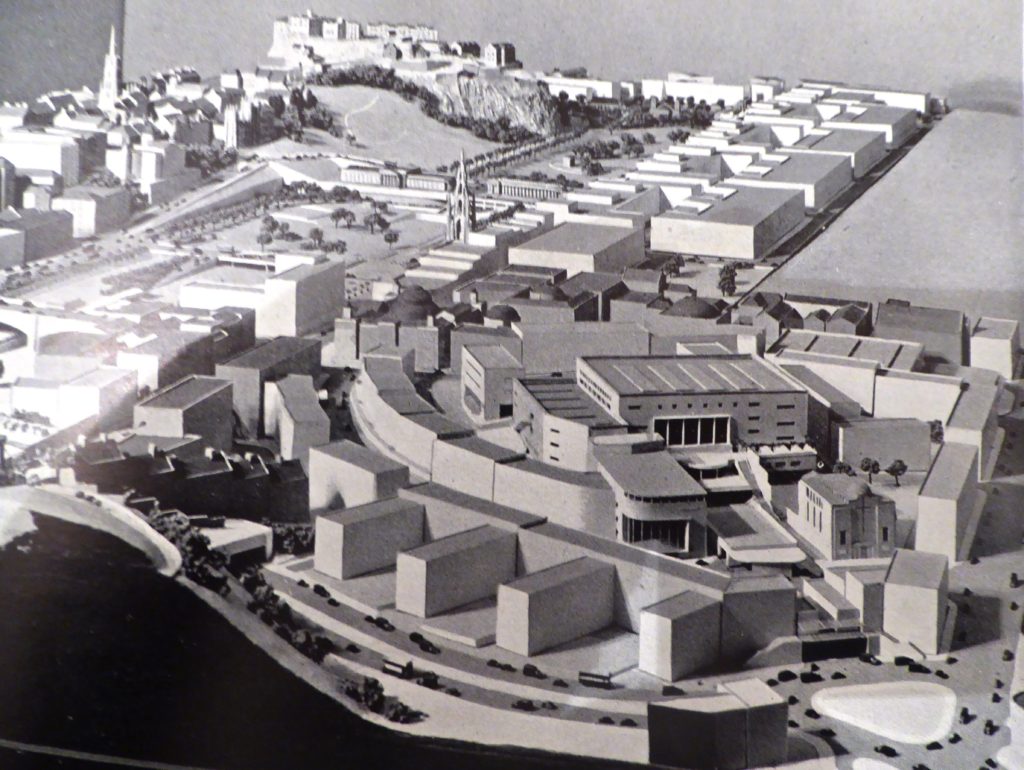
For the past three years the top end of Leith Street in Edinburgh has bristled with large, brightly-coloured hoardings. They’re heralding ‘Edinburgh St James’, the shiny new ‘retailopolis’ that’s now emerging from the building site that spawned it. If the artwork is to be believed – and why shouldn’t it be? – the new urban extravaganza will be peopled almost exclusively by young folk toting bags with fashionable labels, talking into their smart phones, absorbed in their laptops or carrying cartons of coffee (capuccino or lattes presumably).
I’ve already decided it’s not for me. I’m too old, too shabby, too grumpy. Besides, I like my coffee from a china cup and prefer a telephone with a house attached.
Still, I’m glad to see it happening. According to the new scheme’s designers – Alan Murray Architects – we can expect something ‘ambitious and bold… a vibrant exciting place to live, visit and shop in the heart of Edinburgh.’ A billion pound’s worth of shops, hotels, cafes, cinemas, restaurants, flats, aparthotels complete with 20,000 square metres of underground car parking. Not so much a shopping centre, says Edinburgh St James boss Martin Perry, ‘but a mixed use environment.’
Well, maybe. But whatever finally emerges in that corner of Edinburgh has got to be an improvement on what was there before – the St James Centre, that notorious array of dark, concrete-clad buildings that became the most roundly disliked modern architecture in Scotland. They were buildings that the Architects Journal described as ‘a monstrous aesthetic and social blot’ and which were characterised by that waspish aesthete, the late Sir Nicholas Fairbairn MP, as ‘a disgrace to planning, an offence to the eye, a wound to our city, a monument to profligacy.’
A gallows hill
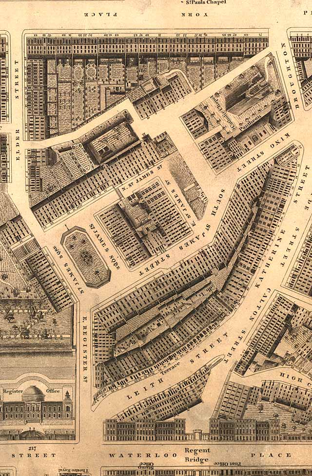
But then, nothing on that incline at the east end of Princes Street has been easy. Known for decades as Moultrie’s Hill, it was one of the places in Edinburgh where they used to hang miscreants. It was a fought-over strategic position in the late 16th century war between the supporters of Mary Stuart and those of her son James VI. Then, for generations, the hill was lorded over by Heriot’s Hospital that battled with anyone who tried to usurp its ownership. So when one of their feu holders, Edinburgh lawyer Walter Ferguson, announced plans to develop a site on Moultrie’s Hill the trustees of Heriot’s Hospital took him to the Court of Session. Heriot’s lost: Ferguson won.
In 1773 Ferguson commissioned James Craig, the young architect/planner who laid out the New Town, to put together a scheme to develop the site. The result was a document entitled Plan of a new designed square. The Property of Mr.Walter Ferguson, Writer in Edinburgh. Craig visualised four banks of tenements arranged in a square with a central garden and ‘garden greens’ behind every terrace. The accompanying blurb is a fine example of a late 18th century sales pitch aimed at Edinburgh’s growing middle class.
The new square, it said, was ‘dry and healthy and commands pleasing and extensive views’, it was a mere ‘8 minutes from the Parliament House, the High Church and the Exchange… 6 minutes from the markets and not 3 minutes from agreeable airing in the country.’ Most important of all, perhaps, being outside the city boundary ‘it is free of all the Taxes, imposts and burdens to which the inhabitants within the Liberties of the City of Edinburgh are subjects; and of the land tax.’ Which was not a bad pitch: high, dry, close to the action and tax-free. What was not to like?
The first cornerstone was laid in June 1775, watched by a sizeable crowd. Being on Moultrie’s Hill the occasion was enlivened by two of the builders falling out and resorting to fisticuffs. But the Craig/Ferguson project still went ahead and by 1780 the first houses in St James Square (possibly called after James Stuart, the ‘king over the water’) were open for business. The new square quickly attracted a decent – if not very wealthy – bunch of renters, many of them refugees from the squalor of the Old Town. Some became noteworthy, others were seen as dangerous Jacobites. Among them was Robert Burns who lodged in the square on one of his jaunts to Edinburgh in search of fame and fortune.
A social mix of all sorts
But the square’s role as one of Edinburgh’s fashionable high spots didn’t last. The later and much posher New Town – e.g. Robert Adam’s Charlotte Square – proved a powerful draw to Edinburgh’s elites. They headed west, leaving St James Square and its surrounding streets to slide slowly down the social ladder. But not too far or too fast. Judging from the Edinburgh and Leith Post Office Directory of 1851-52 (and the 1851 census returns) by the middle of the 19th century St James Square had developed into a lively, busy, socially-mixed quarter of the city accommodating professions and trades of all descriptions.
The same directory lists a painter, an architect, a surgeon, a builder, a cabinet maker, an upholsterer, a commercial agent, a glazier, a chaplain, an enameller, a saddler, a water officer, an accountant, a coal merchant, another three messengers-at-arms and Carl Pein, ‘professor of the oboe.’ Elsewhere in the St James quarter: a cowfeeder, a bootcloser, a mail guard, a stamper, a letter-carrier, a billiard-table maker, a midwife, a baker, quite a few wrights (one a female), a ladies nurse and a veterinary surgeon.
Plus, of course, businesses of varying sizes. Along with the usual string of butchers, bakers and grocers, there were W.H. Lizars, the famous engraving firm, William Murray, the upholsterers, R. Tullis & Co, papermakers, Schenek & McFarlane, lithographers, the ‘Trade Protection Circular’, Wilson’s Albion Hotel, Scougall & Drysdale grocers, a branch of the British Linen Company bank, the office of the Post Office Directory and a Police Station.
Plainly, in 1851 St James Square and the attendant streets had a lot going for them. It’s hard to think of any quarter of Edinburgh these days so rich and varied in the skills and trades of its inhabitants. I suppose it’s what modern property developers and estate agents would describe as ‘vibrant’ (although it’s hard to imagine that being applied these days to a ‘professor of oboe’ let alone a ‘cowfeeder’ or a ‘bootcloser’).
Poverty, greed and neglect
But, alas, it didn’t last. The rot had set in, thanks mainly to poverty, unemployment and the greed and neglect of landlords. Excessive sub divisions saw five or six families being crammed into flats designed for one. By 1865, the year of Henry Littlejohn’s famous report on the city’s health, the St James Square area had around 2,500 inhabitants, an appalling death rate (particularly among infants), was grossly overcrowded and had common stairs into which the lavatories ventilated. Noxious slums, in other words.
And that, more or less, is how they stayed for the next hundred years. In the decades following World War I, the square was in a sorry state and a by-word for poverty, alcohol abuse and prostitution. In the words of one Edwardian wag: ‘Our Bohemia, if it is anywhere, is round the Register House’ (i.e. St James Square). Which was certainly not what Walter Ferguson and James Craig had in mind for Moultrie’s Hill.
But a site just behind the east end of Princes Street plainly had potential. That was spotted by Patrick Abercrombie in his grand plan of 1949 for the post-war revival of Edinburgh. In Abercrombie’s view the St James Square area was the ideal place for Edinburgh to flex its cultural muscles by building a spacious new concert hall/opera house together with all the trappings. Abercrombie took the idea seriously enough to include plans, sections and elevations in Appendix V of his report. It’s all a bit sketchy (particularly the elevations) but it’s not a bad scheme. It certainly would have enlivened the dour Edinburgh of the 1950s and early 60s.
Here’s how Abercrombie described Moultrie’s Hill’s potential:
The St James Square area was selected because it offers a natural compact area… with magnificent views from its steep slopes to Leith Walk, the Firth of Forth and the Fifeshire mountains. Here it is suggested that Edinburgh might find the most appropriate site for a Civic Theatre and Concert Hall with music practice rooms and lecture rooms in the upper storeys… The huge building would be approached from St James Square…
Pie in the sky
The idea was for the theatre/arts complex to step down from St James Square into Leith Street with the main (pedestrian) entrance on the former and a rear entrance on the latter. The project over three floors included two concert halls, a lecture theatre, a small ballroom, a cinema, two restaurants and a ‘coffee lounge’ and a rebuilt Theatre Royal (the original having burnt down in 1946). There was also ample (for 1949 anyway) car and bus parking in the sub-basement. Abercrombie’s idea would have given Edinburgh what the fledgling Edinburgh International Festival needed (and what it spent the next five decades demanding) – a decent opera house.
Abercrombie’s ‘suggestion’ for Moultrie’s Hill had some serious backing but in the end it came to nothing. Edinburgh never rose to the challenge. Important politicians were noisy in their objection. It was pie in the sky. The money was not available. Post-war Edinburgh had other, bigger, priorities. So St. James Square remained the province of a handful of small businesses and workshops and 3,700 or so of Edinburgh’s lower orders and their exploitative, ever-neglectful landlords. The long decline of James Craig’s tenement buildings continued. Rack followed ruin and ruin begat rack.
This is Part One of George Rosie’s three-part story of the rise, fall and rise of the east end of Princes Street.
Part Two investigates the new brutalism of the second part of the twentieth century.
Leave a Reply