
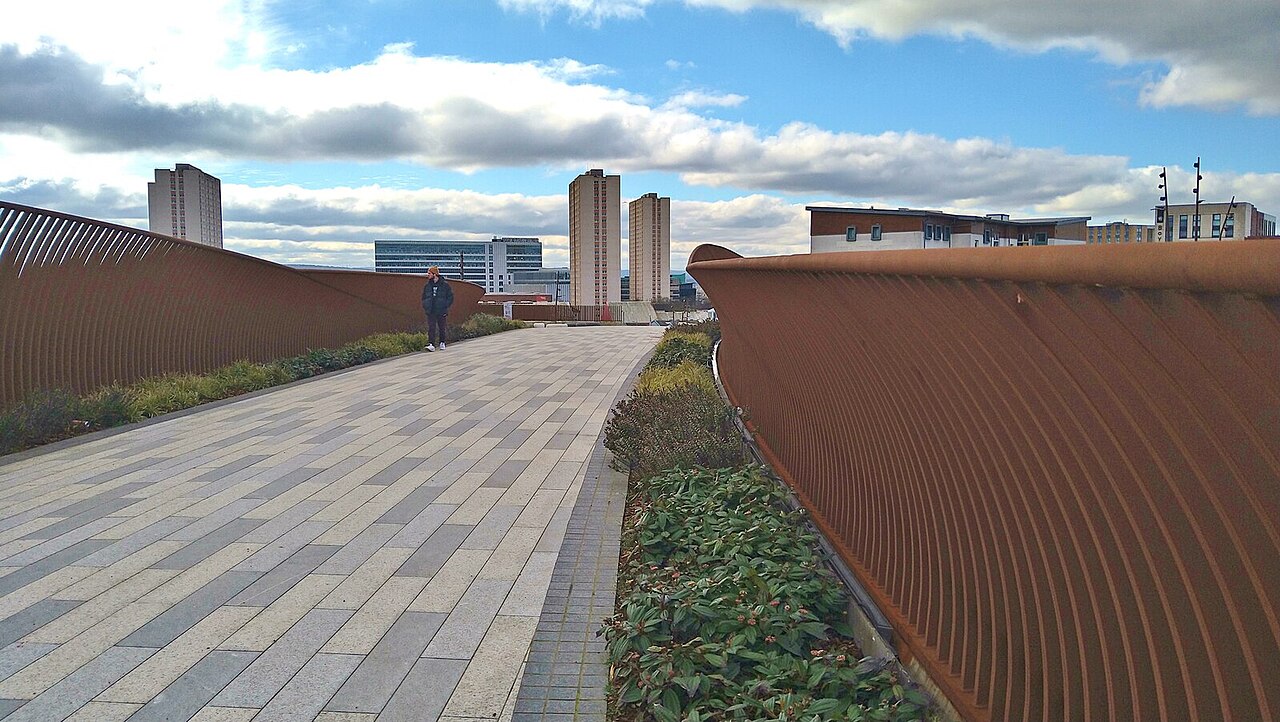
“The paths are being used. People walk, cycle and run here, for leisure or simply to get from one place to another. The routes link major residential areas such as Sighthill and Springburn, so they have a purpose beyond recreation.” Charlie Ellis takes a walk over Sighthill Bridge and sees the city from a new angle.
The new Sighthill Bridge in Glasgow shows what good infrastructure can do for an area. Weighing 1,000 tonnes and stretching more than 74 metres across the M8, it is a centrepiece of the £250 million regeneration of Sighthill, which includes more than 800 new homes.
Built by BAM Nuttall at a cost of £18.4 million, it replaces the old North Wallace Street footbridge, which the council had judged ‘not fit for purpose’. That seems fair enough. The old bridge was narrow, with traffic pressing in on both sides, making the crossing feel cramped and unpleasant.
The new bridge is a very different experience. Part of a wider landscaping scheme, it offers a broad, gently curving route north, with a deck that varies in width from 7.5 to 20 metres. You approach through the landscaped Sinew Gardens before being eased over the expansive bridge. It feels secure and spacious; there is little chance of vertigo striking here. For much of the crossing, the M8 is barely visible. You feel more as though you are walking along a landscaped path than crossing a motorway.
The bridge leads towards Port Dundas, an important part of Glasgow’s industrial past. It also connects Sighthill to the Forth & Clyde Canal cycle route and provides a more inviting link towards the city centre. But there is more to it than making a journey easier. The bridge is a reminder of how the M8 and the roads around it have carved up Glasgow, leaving neighbourhoods physically close to one another but awkwardly disconnected.
Crowded but walkable Edinburgh
The main obstacle to getting around the centre is more likely to be a crowd of tourists than a stream of traffic.
Glasgow and Edinburgh are regularly compared, often unfavourably for Glasgow. The state of their main shopping streets, Princes Street and Sauchiehall Street, has attracted plenty of comment. Veteran journalist Andrew Neil, for instance, described Sauchiehall Street as “a shambles and a disgrace to Scotland’s biggest city”. But there is another difference between the two cities that deserves attention: the ease, or otherwise, of getting around on foot.
The first junction on Sauchiehall Street, at West Nile Street, lies just 350 metres from the M8 as the crow flies. Walk the same distance north from Princes Street in Edinburgh and you reach Queen Street. It is a busy road, certainly, but a long way from being a motorway. And although you can spend what feels like an age waiting for the lights to change, you can still cross without much difficulty.
Edinburgh generally feels like a more continuous city, with relatively few roads that are difficult to cross. Parts of the West Approach Road are an exception. The main obstacle to getting around the centre is more likely to be a crowd of tourists than a stream of traffic.
Severed and fragmented Glasgow
The north of Glasgow is perhaps the least discussed and least visited part of the city.
In Glasgow, the M8 severed Port Dundas from Cowcaddens and the surrounding areas that it once served. The new bridge is one small attempt to put that right. Just how fragmented Glasgow can feel struck us recently when we picked up a copy of the Glasgow Sustainable Food Directory. It divides the city into separate sections to cover its different areas. This is hardly scientific evidence of a divided city, and a directory has to be practical, but it is a reminder of how difficult Glasgow can be to take in as a single place. Edinburgh could probably be covered on one map, with perhaps only outlying areas such as Granton requiring a separate panel.
The north of Glasgow is perhaps the least discussed and least visited part of the city. The West End has a well-established identity, while the South Side, particularly around Queen’s Park and Shawlands, has grown in prominence and popularity over recent decades. More recently, the East End has become fashionable, attracting property developers to places such as Wellpark. Now the north is seeing major development of its own.
There is something telling about arriving at Queen Street station by train. The railway passes through this part of the city before disappearing into a long tunnel, and you get little sense of what lies beyond. It is an odd way to encounter a sizable part of Glasgow, and perhaps helps explain why the north has remained out of sight, if not quite out of mind.
New life on the waterside
The transformation is far from complete, and there is something appealing about that. Along one stretch of the basin, lilies float beside a semi-submerged shopping trolley and an empty bottle of Buckfast.
The area around the Forth & Clyde Canal makes the effects of this disconnection particularly clear. Port Dundas is only a 15-minute walk from Sauchiehall Street, yet it can feel like a frontier on the edge of the city. Around the large canal basin, relatively little remains of its industrial heyday. Even so, it is an attractive setting, and Glasgow is beginning to follow a familiar pattern from elsewhere in Britain: former industrial watersides being turned into places to live, work and spend time outdoors.
London’s Regent’s Canal, Fountainbridge in Edinburgh and the redeveloped waterfronts of Manchester all offer examples of this shift. Liverpool’s Royal Albert Dock is another, with its old industrial buildings put to new uses. Glasgow had an early example of its own at Spiers Wharf, first redeveloped in 1989. For years, though, it felt rather isolated: a little pocket of West End-style living and working on the northern side of the city, without much connection to its surroundings.
That is beginning to change. New paths and cycle routes are linking the canal to other parts of Glasgow, including routes through Maryhill towards the West End. The waterside is becoming easier to reach, not just as somewhere to go for a walk but as part of the way people get around the city.
The transformation is far from complete, and there is something appealing about that. Along one stretch of the basin, lilies float beside a semi-submerged shopping trolley and an empty bottle of Buckfast. It is, some may suggest, a very Glasgow combination. The place has not yet been tidied up to the point where all signs of its past, or present, have disappeared. There are still rough edges, and the canal has not become just another sanitised waterfront development. Not yet.
A new and clearer view
Even from the canal, the city centre seems to sit below you.
The paths are clearly being used, though. People walk, cycle and run here, for leisure or simply to get from one place to another. The routes link major residential areas such as Sighthill and Springburn, so they have a purpose beyond recreation. Much of the surrounding land is still empty, although new housing is beginning to fill in what can feel like a semi-wilderness. Some of the new homes, such as those on Harvey Street, sit high on the hillside, with, I imagine, remarkable views across the city.
Even from the canal, the city centre seems to sit below you. The changes in level reveal a variety of buildings and architectural styles, offering a different view of Glasgow’s shape and character. Edinburgh is often celebrated for its hills, but central Glasgow has its own dramatic topography: Garnethill rising above Sauchiehall Street, the Necropolis looking down over the East End, and Gilmorehill, where the older buildings of the University of Glasgow occupy such an imposing position.
One reason to explore this part of Glasgow is simply to see the city from a different angle. From the canal basin and the surrounding hills, you get a sense of its scale and variety, but also of the gaps that decades of road-building and uneven development have left behind.
The Sighthill Bridge will not undo all that, of course. A bridge cannot compensate for a lack of investment in the neighbourhoods around it, and better connections are only part of what makes an area work. But it does make a crossing that was once unpleasant into somewhere people might actually want to walk. It brings parts of the city closer together in a way that is both practical and symbolic. For a city so often divided by its roads, that is no small thing.
Feature image: The magnificent new Sighthill Bridge: photo Gordon Brown CC BY-SA 2.0

Leave a Reply